Cold week on tap: first freeze Tuesday or Friday
NWS forecast discussion states: “Windy conditions will persist through the latter half of Monday morning but starts decreasing by the afternoon as surface high pressure starts building across the Central Plains starts weakening the pressure gradient across our area. With the cold front well through our area pushing across northern Texas, it will be a cooler Monday afternoon with below normal highs in the 50s. Cirrus will continue to increase in our zonal flow aloft further limiting afternoon solar heating. High surface pressure then builds in Monday night with winds going light and variable to calm. Although high cloudiness will linger, conditions will still favor strong radiational cooling Monday night with a more widespread freeze across our area as far south near the Red River. Northern and western Oklahoma will likely go subfreezing in the mid to upper 20s while western north Texas may hover just above freezing with slightly moister air/higher dewpoints in place. 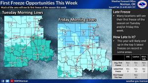
“Also keep in mind that Mesonet 2-inch depth soil temperatures are still rather warm in the 50s.
“South winds make a brief return on Tuesday starting a two-day warming trend before our next cold front passage. However still seeing cooler than normal high temperatures for Tuesday afternoon and not as cold (40s) overnight with breezy south winds.
Could see a broad range of temperatures on Wednesday as surface boundary takes shape just north of the area and drops quickly south during the day. South of this front, temperatures will respond to the south winds with temperatures climbing into the 60s and 70s. Further north temperatures may make it into the 50s before possibly falling temperatures Wednesday afternoon.
“Main upper wave still makes its way east across the southern Plains Wednesday night and not completely out of the question to see some light rain, however current forecast remains dry. Many areas will not climb out of the 40s Thursday or Friday before a bit warmer day expected Saturday. However, this looks to be short-lived as yet another cold front sweeps south through the area Saturday. This front may tap into more Canadian and possibly Arctic air and could bring the coldest temperatures of the season to the southern Plains.”